New race! It'll be fun! Dr. Horton is helping direct it!
That's pretty much all I had heard about this race when I signed up. That in itself was a very different experience. I have been spoiled by being late to the game with trail running, and benefiting from many, many race reports and friends who shared their course knowledge. Even if I hadn't been on the course before race day, every other race I at least knew something about what I was getting into.
Not so with this race.
I didn't know exactly how long the race was (well, that's not terribly unusual for a Dr. Horton race). Until about a week before the race I didn't know how many aid stations there were, how far apart, how much road in the race, etc. All I knew was there was some infamous "death climb" that Dr. Horton was excited for all of us to experience.
It certainly added an interesting element of mystery and intrigue to run, guessing as best I could where to push myself and where to hold back, since I knew so little of the course. It was a different sort of challenge than I usually get at these races and I enjoyed being a part of an inaugural year for a race.
But I know there are plenty of other runners out there like me who love to plan ahead and read race reports and course descriptions before deciding to run a race. So in the interest of giving back, I am writing a course description, as best I can remember, of this race, hopefully benefiting future runners.
Course Overview

Total Distance: 32.33 mi
Total Elevation Gain: 5,000 ft
Total Elevation Change: 10,000 ft
The course is a figure 8 style course. The first loop is almost 21 miles long, and the second loop is a little over 11 miles long. The only repetition in the two loops is approximately 2 miles before you come into the main start/finish area.
The race was well-organized. You come into an area closed off by barbed wire and actually need to sign security clearance papers before entering the parking area (which is behind lots of interesting signs, like "Hard Hat Area" and one describing how the magnetic fields will interfere with pacemakers). There were plenty of parking attendants and signs, it was very clear where to go. Checkin was quick and easy. The bathroom building at the start/finish was not functional but there were several portajohns set up for runners and aid station workers.
Start to AS 1 (Mile 0 to Mile 4.2)
Dr. Horton's description:
"Cross the bridge and head up the hill towards the Visitor Center, at .6 mile turn right at the top of the hill on a road to the right, go steeply up the hill. Reach the top of the hill and go around the gate onto Silver Dollar Road. Pass the tower on the left at 1.55 miles. Continue on the gravel road to the paved road. Reach Toler's Ferry Road (608) and Aid Station 1 at mile 4.27. Turn right and follow Toler's Ferry Road."
My thoughts:
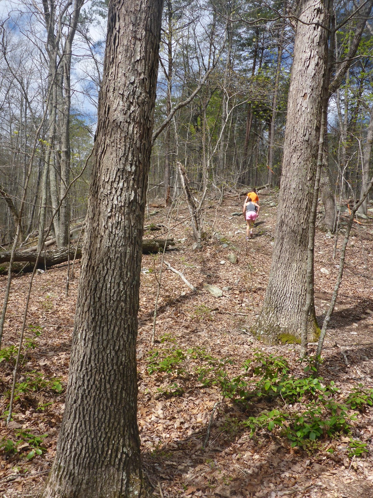
There was little to no warmup in this race. We ran across the bridge and started climbing almost immediately. Dr. Horton had mentioned a "good climb" near the start, but none of us knew how steep or long. The answer? Very steep and fairly long. The first mile took us almost 18 minutes. We gained almost 1,000 ft in the first mile and a half. The first half mile is uphill on a road, and then once you reach the Visitor Center you turn right onto a steep and rocky trail. Then you climb and climb until you're starting to wonder if signing up for a 50K was such a great idea, and whether you will be able to run another 30 miles on these legs. Then you climb a little farther. There was one place where you come to a sort of clearing near the power lines and it looked like maybe you were at the top, but then you turned right and continued to climb for a few more minutes before it levels out. There were some beautiful views running along the ridgeline at the top. The next few miles were quite nice, on various dirt and gravel service roads. The trail was mostly down for the next mile and a half or so, and then it was rolling with some very runnable ups and downs until reaching the aid station at mile 4.2 or so.
 |
| The first climb, after turning at the visitor center |
 |
| View from the ridgeline |
 |
| Service roads leading to AS 1 |
AS1 to AS 2 (Mile 4.2 to Mile 8.5)
Dr. Horton's description:"Turn right and follow Toler's Ferry Road. Green Gate on left side of the road at the bottom of a hill is AS 2 at mile 8.58."
My thoughts:
After the aid station, we immediately turned right onto a paved road. This section was mostly down with a few short climbs until the trail bottomed out shortly after mile 7. The roads were pavement but very pretty and very runnable, especially so early in the race. Around mile 7.2 we started to climb again, but it was still a lot of rolling hills. The climbs were easy to run/walk, and the downhills were runnable and not steep. We reached the aid station at mile 8.5 right on this road. Shortly before the aid station, on a downhill section the landscape opened up a bit, and instead of being heavily wooded there was a large clearing. When you see this you know you are close to the aid station.
 |
| Paved road section |
 |
| Run/walk climbs |
 |
| Glimpse of the lake about .75 miles before the aid station |
 |
| Looking backwards at AS 2-note the landscape |
AS 2 to AS 3 (Mile 8.5 to Mile 12.7)
Dr. Horton's description:
"Continue on this paved road. Reach AS 3 at intersection of 608 and 672, Ridgeville/Pittsville Roads at mile 12.75."
My thoughts:
Road, road, and more road. By this point, I was truthfully getting a bit tired of roads. Admittedly I rarely run roads and that certainly factored in. But after almost 5 miles, all the rural roads, turns, farmhouses, and abandoned outbuildings were starting to look the same. These miles can feel a bit tedious. There weren't many landmarks in this section, except for a long bridge. The roads were still rolling until approximately mile 11, then there was a longer climb for a little over a mile. The last half mile before the aid station had a small descent and then a section that was relatively flat.
 |
| Most of this section looks like this |
 |
| A bridge with some nice views (and graffiti) |
Dr. Horton's description:
"Reach intersection of 608 and 771 at mile 12.9. Turn right on 771. Reach intesection of 771 and 605, Toshes and Court Roads at mile 14.4. Turn right on Toshes Road. Reach AS 4 at intersection of Jasmine and Toshes Road, 778 and 605 at mile 16.57. This is next to church and cemetery."
My thoughts:
This section starts out with a nice runnable descent (assuming your legs aren't hurting too much from the pounding pavement yet), until bottoming out around 15.2. Where this bottoms out, there was a portajohn next to a construction crane, right before a bridge. I have no idea if it was supposed to be a part of the race, but for many miles before it, there was either barbed wire or people's yards on both sides of the road. It would have been very difficult to find a place to relieve oneself (although men certainly have an advantage in times like these). At any rate, the portajohn was open and frequented by several runners. It was a wonderful site at approximately the halfway point in the race. Aside from the portajohn highlight, it was mostly just more country paved roads, nothing especially memorable. After bottoming out at the bridge, the road climbed steadily to the aid station.
 |
| Many miles of country roads and scenery |
AS 4 to AS 5 (Mile 16.5 to Mile 21.2)
Dr. Horton's description:
"Turn right on gravel road which is Toshes Road. At mile 17.38 turn left on Yorkshire which is a paved road. At Ford Road which is mile 19.04, turn right on Ford Road (908) and proceed back to the starting area. Reach AS5 and the starting area and the restrooms at mile 21.30."
My thoughts:
After aid station 4, we turned onto a more gravel/dirt road, which offered a blessed reprieve from the pavement. There was a sign about a sandwich shop which sounded delicious at about this point. We ran mostly downhill on this gravel road. Sadly, the gravel ended after less than a mile, as we turned onto another paved road. On the bright side, I knew this meant we were getting closer to where we had started and therefore the end of the loop. While the first mile of this section was downhill, the next two miles saw us steadily climbing back towards the road we had driven in to get to the start. At the sharp right, there was a police car blocking the road and an officer directing us to the right. Definitely won't be missing that turn! From there we climbed for another mile. This road was much busier than any of the other roads we ran on so far, but there was plenty of room to run on the shoulder for most of the way and the road was wide. After a mile on this road, we started to descend. This was a nice runnable descent, and it felt good to stretch the legs out. At one point there is a sign warning of sharp turns and a 25mph recommended speed. From this sign, it's less than a mile (around 0.8 miles I believe) back to the starting area. We ran down for a half mile after this sign, around the curves, until we saw the entrance to the visitor area. Around the corner to the left, and we were soon directed to move to the bike path on the right side of the road. A short stint on this paved bike trail brought us back to the starting area and the aid station at the conclusion of this first lap.
 |
| It doesn't actually go on forever. But close. |
AS 5 to AS 6 (Mile 21.2 to Mile 22.5)
Dr. Horton's description:
"Turn left in front of the restrooms and go straight across the road onto a single track trail. Ascent the mountain on the DEATH CLIMB. Reach AS 6 at mile 22.7 at the top of the Death Climb."
My thoughts:
Leaving the aid station, we crossed the road onto a trail. Hooray! It was a refreshing change of pace (literally) from the last 17 miles of road. The trail started out very pretty, wooded along a stream. We crossed back and forth across the stream a total of 8 times. The footing was challenging at times, but it was fun. The stream was deep enough to get your feet wet in a few places, and deep enough to splash some cool water on your face if it's hot. Then there was a short section that didn't look like a trail at all, but a clearing where a storm had knocked down several large trees. And after that began the infamous Death Climb. I had been hoping/expecting that Dr. Horton was exaggerating his claims of this climb. He was not. It most certainly lived up to its name. This was the most difficult climb I have ever done in any race. According to my garmin, we gained over 1200 feet in exactly one mile. That's insane. That's approximately a 22.7% grade. Like a ski hill. Only covered in thick trees, roots, and rocks. I saw many runners simply sitting down at this point. I was afraid to stop and catch my breath without holding onto a tree; I really thought I might just lean back and fall off the mountain. I've done longer climbs than this in a race. I've done climbs that gained more elevation. But never have I climbed something so intense for so long. It was almost comical, how ridiculously steep it was. Pictures hardly do it justice, but I tried. There were some nice views looking back as we climbed.
 |
| Entering the trail after the aid station |
 |
| One of the 8 stream crossings |
 |
| Trail or natural disaster zone? You be the judge |
 |
| Up, up, up |
 |
| Yes, they really are about 50 feet above and 10 feet in front of me |
AS 6 to AS 7 (Mile 22.6 to Mile 26.2)
Dr. Horton's description:
"Continue on the gravel road along the ridge with GREAT views to the right. There are several climbs and descents along this ridge. Reach AS 7 at mile 26.35 at Lakeview Gap still on the gravel road and the ridge."
My thoughts:
After such a long and difficult climb, we at least deserve some great views, right? This did not disappoint.
 |
| View from near AS 6 |
 |
| Dirt road leaving the aid station |
 |
| We are going up again?? |
 |
| Very pretty descents |
AS 7 to AS 8 (Mile 26.2 to Mile 29.4)
Dr. Horton's description:
"Reach bottom of hill and Jasmine Road (778) at mile 27.50. Turn left on Jasmine Road which is still a gravel road. Go to AS 8 at the intersection of Jasmine and Yorkshire Roads (777 and 778) and mile 29.55."
My thoughts:
We continued our long steep descent down the mountain. Altogether, we descended about 1000 feet in under 3 miles, all on loose gravel roads. We went down for over a mile before encountering any sort of climb at all, and even then there were only a few very short climbs to mile 29. This was not an easy runnable down, it was steep and the gravel was loose, so it was the sort of downhill that took concentration and cooperation from your quads. After hitting mile 29, we climbed for a short ways up to the aid station. I don't have any pictures in this section due to a camera malfunction-sorry!
AS 8 to Finish (Mile 29.4 to Mile 32.3)
Dr. Horton's description:
"Turn left on the paved road Yorkshire (777), go to intersection of Ford and Yorkshire. Stay left on Ford Road and continue to the finish at mile 32.47."
My thoughts:
Immediately after the last aid station we turned left on yet another paved road. We went steadily downhill on this paved road for almost a mile. There were a few small creeks and a lake in this section that were accessible for splashing our heads and faces in the heat. Then we began climbing again, a climb that would have been runnable in the first ten miles but was definitely a run/walk hill for us at this point. We climbed up to the intersection where the police officer directed us to turn at the end of the first loop. We ran the same road in, steadily climbing for about a mile before starting to descend on that road to the visitor center. At last we saw the 25mph sign, and knew we had less than a mile to go. Around a few corners, over to the bike path, and the finish was just across the small bridge on the bike path.
 |
| Steady climb in the last 2 miles of the race |
Overall Impressions
This was a well-organized race, especially for a race in its first year, with multiple distances (there was also a 5K event). There were many aid stations, with the longest distance between aid being only 4.7 miles, which made it easy to just carry a handheld water bottle. The volunteers were friendly and helpful at every aid station. The course was well-marked. I would have appreciated a few more confidence streamers in places, but every turn was easy to spot and we had no trouble staying on course. It was exposed though-I wish I had worn sunscreen.
If there's anything to improve on, it would be small details. The aid stations were like candy stores-lots of chocolate candies, M&Ms, gummy bears, cookies...with very little substantial food, fruit or salty snacks. They did have potato chips at most aid stations. I would have appreciated some PB&J, pretzels, grapes, etc. And the soda was in cans, not opened-I'm sure that the volunteers honestly thought we would prefer fresh fizzy soda, but most of us find it much easier to drink soda that's a bit flat. And maybe skip the diet soda in favor of something with more calories and caffeine. These are very minor things though that would be easy to adjust. The aid stations all had ample helpful volunteers, plenty of water, and lots of food.
I would also have appreciated more restroom access. Many many road miles with no official portajohn stops can make for an awkward race. Perhaps one of the small churches we passed would be willing to accommodate future runners on the course. And there was a nice restroom building at the start/finish, but for some reason it was not functional. It would have been nice to have a real restroom and changing area at the finish.
There was no post-race food included in the price of the race, although there were some food trucks at the finish with food available for purchase. I wish I had known to plan for that, and what options would be available with approximate costs.
The finishers' shirt was a very nice tech t-shirt, plus we received a regular cotton shirt when we checked in. I especially like how the finishers' shirt is extra long and fits nicely.
The Top 10 awards were also very unique and specific to this race. They were special trophies made to hold one of the core samples they took when building the dam. Admittedly, part of why I think this is great is because I am not normally a top 10 finisher. It was pretty fun to win an award and be in the top women's picture, since I am usually in the mid to back of the pack. So thank you to all the women who didn't run, I owe this trophy to you. :)

The Top 10 awards were also very unique and specific to this race. They were special trophies made to hold one of the core samples they took when building the dam. Admittedly, part of why I think this is great is because I am not normally a top 10 finisher. It was pretty fun to win an award and be in the top women's picture, since I am usually in the mid to back of the pack. So thank you to all the women who didn't run, I owe this trophy to you. :)

Would I run it again next year? I'm not sure. There were an awful lot of road miles for this trail runner. I don't train on roads, and found it tough to deal with so many miles of pavement. Yet I'm not sure this would be a road runner's favorite either, because the trail sections-while relatively short as far as mileage-are quite rigorous and demanding. I did very much enjoy the challenge of the two big climbs, the one at the start and the Death Climb, and the views were gorgeous.
If they created a 25K option, by combining the 5K course and the 2nd loop of the 50K course, I would definitely run that. I think a middle distance option here would be very appealing. The Death Climb would be a bit gentler on relatively fresh legs, and the 10 miles of gravel and paved roads would be far less pounding. Another good suggestion was to make the second loop just a little longer and turn it into a half marathon. A middle distance like that could appeal to either road or trail runners. Just my opinion though.
I'm grateful for a well-organized race, a beautiful day in the mountains, gorgeous views to enjoy, friends to run with, and a chance to be a part of something new.
 |
| From left: Myself, Rhonda, Dr. Horton, and David |